Submitted by mihai.niculita on Sun, 11/08/2020 - 12:46
Această pagină web listează resurse legate de crearea și prezentarea referatelor, în special a celor cerute studenților la diferite discipline din facultate.
Prima abordare a acestui subiect a fost realizată în cadrul proiectului ROSE GeoDA (14 decembrie 2017, sala B664), pentru studenții anului 1, din cadrul Departamentului de Geografie, a Facultății de Geografie și Geologie, Universitatea Alexandru Ioan Cuza din Iași (”Devino absolvent al Facultății de Geografie și Geologie din Iași! - GeoDA” - AG 31/SGU/NC/I. director Lect. dr. Alex Bănică).
Submitted by mihai.niculita on Fri, 04/17/2020 - 08:44
Climate change driven by humans is a certitude, with uncertainties regarding the level of climate variability. This variability will influence natural hazard processes and the climate change uncertainty is transferred also to natural hazard modelling. The uncertainty is further multiplied by the fact that humans continue to modify the land surface, thus influencing the natural hazards, especially in the case of landslides.
Submitted by mihai.niculita on Thu, 04/16/2020 - 06:29
Archaeological topography identification from high-resolution DEMs (Digital Elevation Models) is a current method that is used with high success in archaeological prospecting of wide areas. I present a methodology through which burial mounds (tumuli) from LiDAR (Light Detection And Ranging) DEMS can be identified. This methodology uses geomorphometric and statistical methods to identify with high accuracy burial mound candidates. Peaks, defined as local elevation maxima are found as a first step.
Submitted by mihai.niculita on Thu, 04/16/2020 - 06:27
Hilly regions around the world are one of the most vulnerable places for inhabitation, where landslides represent a permanent threat for their population. In some particular cases, in the past, due to their topographic features, areas affected by massive landslides served a real opportunity for the location of strategic and fortified settlements.
Submitted by mihai.niculita on Thu, 04/16/2020 - 04:56
Natural hazards are the most significant threats in rural areas of Romania, while landslides, floods and bank river erosion are the geomorphological processes that impose the greatest risk in the Moldavian Plateau. We have identified 189 of disappeared, displaced and partially affected villages (in the area between Siret and Prut Rivers), using old cartographic materials as primary tool, and overlapping them with the present situation: ortophoto imagery and LiDAR derived high-resolution Digital Elevation Models (DEMs).
Submitted by mihai.niculita on Thu, 04/16/2020 - 04:54
Today, as in the past, people living in hilly and mountainous regions have had to face the consequences of mass movement processes. Archaeological remains are important elements of cultural heritage, which can be significantly affected by landslides in different environmental settings and landscape evolution phases. In the Eastern Carpathians lowlands, landslides have shaped a landscape with inaccessible escarpments tens of metres high, providing ancient populations with naturally defensive sites at which to build their fortified settlements.
Submitted by mihai.niculita on Thu, 04/16/2020 - 04:52
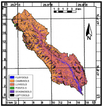
The creation and analysis of landslide inventories is the basic approach for starting the landslide hazard to risk analysis chain analysis. In order to perform this kind of analysis for the Iași Municipality (North–eastern Romania) we created based on aerial imagery and LiDAR data a landslide inventory of the landslide events that happened in the last 100 years. In total, we identified and delineated 518 landslide events: 51.5% translational slides, 19.7% slumps (rotational slides), 17% flowslides and 11.8% flows.
Submitted by mihai.niculita on Thu, 04/16/2020 - 04:50
Iași Municipality as other urban areas around the world has a long history of landslide activity which needs to be studied considering the urban sprawl. We performed a first landslide susceptibility modeling for Iași Municipality based on the AHP method using weights given by expert judgements regarding the influence of preparatory and conditional landslides factors (slope, ruggedness, lithology, historic landslide density and hydrogeology) and weights given by the historic landslide density over the factors.
Submitted by mihai.niculita on Thu, 04/16/2020 - 04:46
Ground deformations are the result of interactions between terrain and various processes. Their identification and monitoring becomes an important step as they can provide insights about Earth’s dynamics or process triggering conditions. This paper aims to show the potential use of Sentinel-1 SAR images to identify ground deformations induced by neotectonics. Hence, we applied PS-InSAR stacking technique on Sentinel-1 ascending dataset in the area of Focșani basin, Eastern Romania. High density of PS obtained in populated areas allows the detection of tectonic fractures.
Submitted by mihai.niculita on Thu, 04/16/2020 - 04:45
SRTM1 Digital Elevation Model for many mountain ranges in Romania were processed to provide slope gradient distributions for each 50 m band of altitude. The effects of cirques are seen in an increase in standard deviation of gradient, and a spread in all percentiles, especially an increase in the 95th, at relevant altitudes. Otherwise, variations in median gradient with altitude differ between ranges, and do not show the general increase found in the Alps below cirque floor altitudes by several authors.
Submitted by mihai.niculita on Thu, 04/16/2020 - 04:35
SRTM data is still one of the most used data in geosciences for various purposes: geomorphometric analysis, environmental covariate modelling or geomorphic change detection. Although high resolution national/regional DEMs exist, very often accessing them is expensive, or their coverage is not complete over specific areas (only floodplains or cities are covered). Because of this SRTM still remains the best choice when elevation data is needed for regional/national or global areas.
Submitted by mihai.niculita on Mon, 07/16/2018 - 23:54
This webpage lists resources related to the creation of maps in GIS.
The first approach to this topic was made in February 2018 within the GeoDA project, for 1st year students, from the Department of Geography, of the Faculty of Geography and Geology, Alexandru Ioan Cuza University of Iași.
Subsequently, the idea was resumed at the JASSY summer school:
JASSY Summer School 9-22 July 2018 Alexandru Ioan Cuza University of Iaşi
“Tourism at the Eastern Border of the EU”.
Interdisciplinary Training for Tour Guides.
Coordinator: Lect. Dr. Mihai Bulai
Submitted by mihai.niculita on Mon, 09/19/2016 - 13:33
Digital soil mapping in a mountainous area with mixed land use (Humor catchment - Eastern Carpathians, Romania) using soil-landscape systems, fuzzy logic and evironmental covariates
Submitted by mihai.niculita on Thu, 02/18/2016 - 01:24
Ce este R?
R este o aplicație de tip open-source, care pune la dispoziția utilizatorului un mediu de programare statistică și grafică statistică. În ultimii ani R a devenit și o unealtă GIS importantă, fiind utilizat în multe aplicații GIS pentru procesare statistică a datelor spațiale.
Interfața grafică în R este minimală, reproducând o linie de comandă, dar spre exemplu aplicația R studio pune la dispoziție o interfață grafică completă.
Submitted by mihai.niculita on Wed, 11/04/2015 - 01:40
Podișul Moldovei este o unitate deluroasă situată în partea estică a României, continuându-se și pe teritoriul Republicii Moldova.
In acest spațiu alunecările de teren reprezintă un fenomen geomorfologic răspândit.
Submitted by mihai.niculita on Sat, 06/22/2013 - 01:42
River channels are landforms created by flowing waters.
In digital format, the river channels can be represented as channels or as polygons.
For their geomorphometric analysis, it is necessary to create the middle line of the river bed. To create the middle line of the river bed, from the polygon topology, it must be transformed into a line, then into points, with the latter filling at a certain distance.
Using Thiessen's polygons, Thiessen polygons will be used.
Landforms, the result of erosion and other geomorphologic processes at the surface of Earth’s crust, have a significant control on soil cover forming and evolution. In the soil-forming equation of Jenny (Jenny, 1945) the “topography” is considered a independent soil system/terrain/environment property, becoming a soil-forming factor.


Recent comments